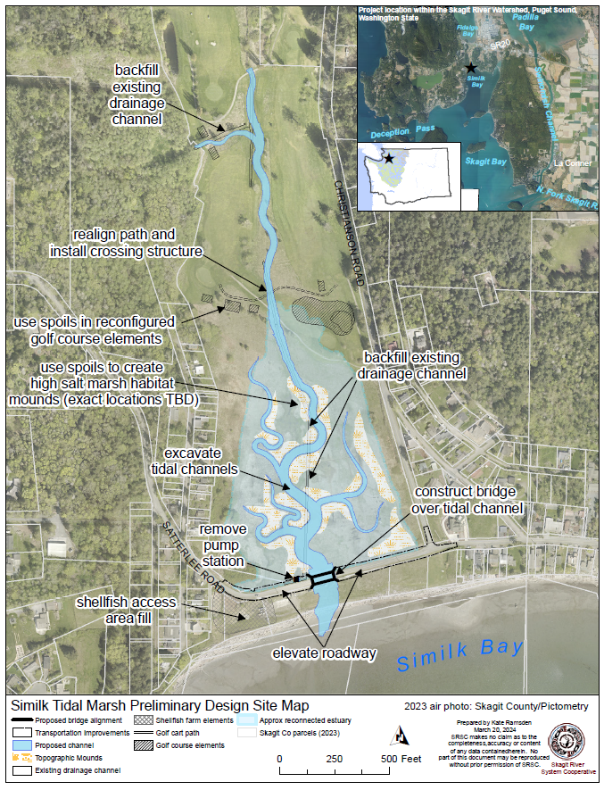
The Similk estuary restoration project is located to the north of Similk Bay, which is at the north end of Skagit Bay in the Whidbey Basin. This pocket estuary project has been a high priority for Chinook recovery since it was initially identified by the Skagit Chinook Recovery Plan in 2005 (p. 218). The Swinomish Tribe and the Skagit River System Cooperative (SRSC) are working together on this project to create 17 acres of salt water marsh habitat for juvenile Chinook.
We will accomplish this by reconnecting tidal influence to the wetland behind Similk Beach by excavating a tidal channel through the beach berm and road and a branching channel network inland. This will create a pocket estuary for juvenile Chinook salmon as they outmigrate from the Skagit River to the sea.
A Coastal stream that drains the golf course through a series of ditches and pipes will also be daylighted and planted with riparian vegetation, providing additional freshwater rearing habitat
We hired Blue Coast Engineering to help us design the physical features of the site to best mimic natural conditions while also avoiding impacts to neighbors and surrounding areas. We’ve undertaken significant hydraulic and groundwater studies as part of years of feasibility work. We have assessed effects on groundwater and any potential effects on septic systems during the design process. Neighbors with potential effects have been identified and contacted. Anyone with concerns should contact SRSC.
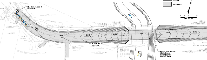
Skagit County has partnered with us to complete this project. Satterlee Road is an important transportation and safety corridor for Skagit County, and the current failing pumphouse is an ongoing liability and maintenance headache for County government. To maintain the road, it will need to be elevated above the high tide elevation and a bridge constructed over the tidal inlet. The failure-prone drainage pump will no longer be necessary as the area drains naturally with the tide. This design also accommodates 2ft sea level rise projections through 2100, building climate resilience into civil infrastructure. The County has given its full official support to the project and its benefit to the fish, the Tribe, and the County.
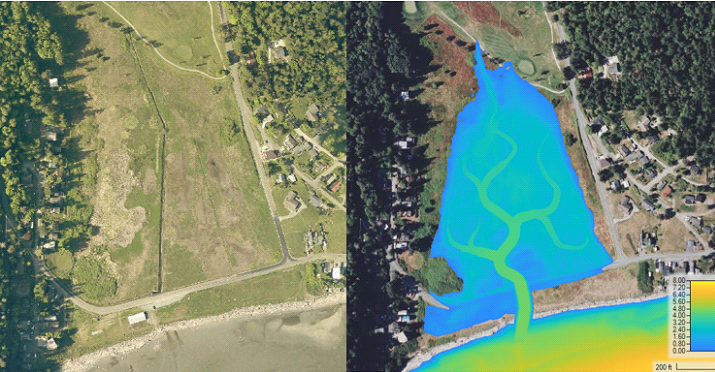
Before/after modeled inundation extent and depths for the current highest astronomical tide based on preliminary excavation plan
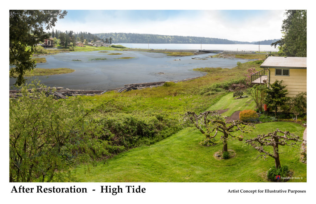
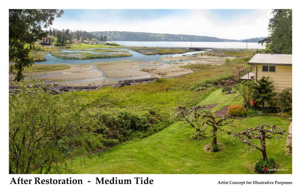
Artist concept for post project after a few years at Medium tide. See more examples on the Outreach page
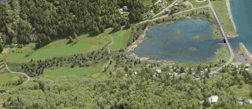
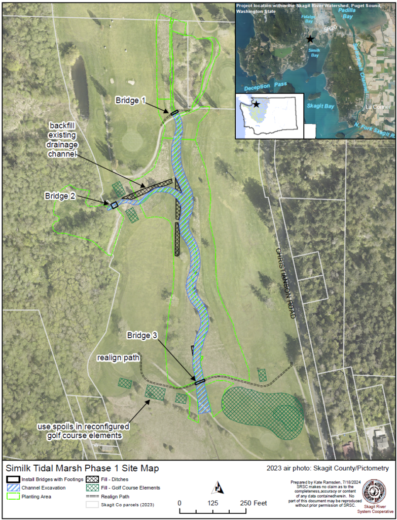
Phase 1 - Freshwater and Golf Course - September 2024
This project has two primary phases – a freshwater phase in the golf course, and a saltwater/infrastructure phase that addresses the marsh and road. While investigating the marsh restoration’s impact on the golf course a significant coastal drainage was discovered in the golf course and was added as a phase of restoration along with reorienting and raising the southern most hole of the golf course. Adjustments to the golf course are necessary to protect it from tidal flooding.
The first phase will be accomplished in September 2024. This phase will excavate 1584 linear feet of new coastal stream channel daylighting the perennial drainage from the golf course.
SRSC has worked closely with the Swinomish Tribe, and the Swinomish Links Golf course leadership and staff to plan changes in the golf course footprint. We will install 3 pedestrian bridges over the new stream channels and plant the riparian areas with native vegetation. We will use excavation spoils from the channel work to reorient hole 5 slightly northward, and raise the elevation of the fairway between 0.5 and 2 feet to protect it from high tides now and in the future. New tees will be constructed for holes 4, 5 and 6, along with adjustments to the cart path, drainage and irrigation.
What is a "pocket estuary?"
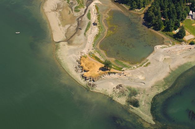
Pocket estuaries are shallow nearshore embayments that are not directly connected to natal streams where salmon spawn and juvenile salmon originate. These places are salmon nurseries when juvenile fish bypass natal estuaries like the Skagit River delta. Similk was historically a pocket estuary that was isolated by a beach berm and road and drained with a ditch network and pump to Similk Bay. Nearby Lone Tree Lagoon and Turners Bay Lagoon are examples of a functioning and connected pocket estuaries. Turners Bay was a very similar project that SRSC completed in 2012 to reconnect a historic estuary to tidal influence. It is now functioning as intended as juvenile Chinook habitat. Once the Similk Restoration project is complete the resulting lagoon it will be at least partially inundated by the tide twice every 24 hours.
Aerial photo of Lone Tree Lagoon, a nearby pocket estuary.
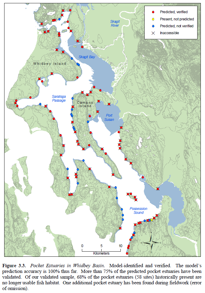
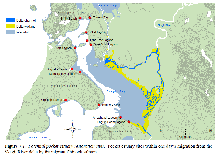
There are many pocket estuaries throughout the Whidbey Basin (Figure 3.3), most of which have been modified or completely eliminated by people. Like the Skagit River delta, these low lying wet and flat areas were viewed by settlers as attractive for agriculture. They were often drained, filled, and disconnected from marine and tidal influence. The Skagit Chinook Recovery Plan (SRSC & WDFW 2005) identified 12 degraded pocket estuaries within a single day’s migration for Juvenile Chinook from the Skagit River Delta. Similk is one of these (Figure 7.2).
Why are pocket estuaries important to Chinook recovery?
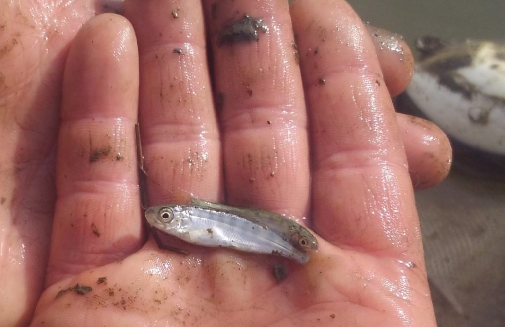
Decades of research in Skagit Bay and the Skagit River delta has established pocket estuaries as important rearing habitat for juvenile Chinook. After these baby fish emerge from their redds in the river, they move downstream toward the estuary. They have a preference for estuary habitat, which provides growth advantages over both upriver and marine habitat. Estuaries are productive environments and serve as nurseries for growing juvenile Chinook. Food is abundant, water is warmer and more conducive to rapid growth, there are many places to hide from predators, and they lie at the transition between fresh and salt water, which eases stress on the physiological transitions freshwater juvenile Chinook must make to become a salt water smolts. These habitats make juvenile fish bigger and stronger, and better able to survive to adulthood in the salt water.
Juvenile Chinook (foreground) and chum salmon. Caught during monitoring activities in the Skagit Bay (SRSC)
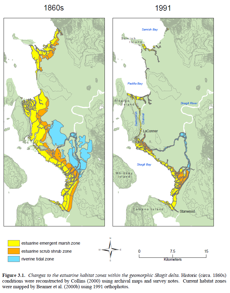
Figure 3.1 compares the Loss of historic Skagit River delta/estuary habitat since the 1860s. Over 86% of historic estuary habitat that juvenile Chinook depend on has been lost to diking, draining, and filling. This loss of habitat means that juvenile Chinook accumulate in the limited estuary habitats and become over crowded. Flooding can also push them out of the river. This forces growing juvenile Chinook to move into the marine areas before they are ready. This is a major bottleneck for Chinook survival and recovery identified by decades of research. Due to rearing habitat limitations, even if more Chinook returned to spawn (such as if fishing were stopped), there is not enough estuary habitat to support the intended increases in their offspring. This is why recovery can only be achieved by increasing habitat capacity through restoration. It is also why fishing moratoriums are not an effective strategy.
Once undersized juvenile chinook enter marine waters they traverse shallow nearshore habitats, and when they find pocket estuaries, they accumulate in them. Pocket estuaries provide many of the same benefits as the natal delta habitat they would usually prefer. In this way pocket estuaries serve as a backup estuary, or a second chance for juvenile Chinook to find rearing habitat. These fish are otherwise be unlikely to survive to adulthood.
Next Steps - 2024
We have completed the preliminary design and habitat and golf course final design where we have chosen an alternative based on transportation and habitat needs and surrounding effects and developed preliminary drawings. We’ve undertaken significant modeling and assessment work, including years of feasibility studies. As of August 2024, all required major permits are in place for the whole project. Some additional minor permitting will be required for Phase 2. The next stage is to complete final designs, particularly for the road and bridge. These designs require significant structural, transportation, and civil engineering. Swinomish and SRSC have partnered with Skagit County to rebuild the road and bridge that will comprise phase 2 along with the marsh restoration. This phase is expected in summer of 2026.
We have held two iterations of community meetings to ensure locals are informed about the project, and to hear any concerns and answer questions. Often communities know their neighboring lands well, and can provide valuable insights that can improve designs. If you have any questions or concerns please contact us using the contact form on the website, and provide your name and address and interest.
We hosted a virtual open house via Zoom on May 10th, 2022, and organized a community site visit on August 7th 2024.
There will be ongoing opportunities as the project develops toward construction, which is likely to be completed in 2026. Please contact us using the form on the contact page, and let us know who you are, where you live, and what interests, concerns, or questions you may have.